This port is precisely located on the southern entrance of Port-Sudan; its length of the fold is 1,765 meters with width of 500 meters. The total area of the southern port is 1,480,000 square meters.

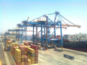
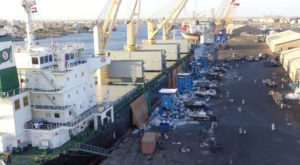 ort also known as north quays its enclosure length is 2,845 meters with width of 300 meters. The total area of the north quay’s is 8,535 square meters and it is dedicated for treating general cargo, edible oil, molasses, dry bulk cargo, liquid bulk and vehicles. The capacity of the north port is 5,000,000 tons per year.
Berths:
(NQ) include (12) berths with length of (1866) meters. Details as follows:
BERTH NO LENGTH DEPTH USAGE
1-2-3-4-5 597M 8.5M General Cargo & Molasses &Cement
5A 229.8M 9.5M General Cargo & Molasses &Cement
6-7 365.7M 10.7M General Cargo & Cement
8-9 365.7M 10.7M General Cargo &Edible Oil
11 106.7M 8.5M Cement
12 201.8M M8.5 Dry Bulk & Cement
Machinery and Equipment Allocated to North Quays in 2014 :-
TON NO TYPE TON NO TYPE
35 3 Mobile Crane 3 14 Fork lift
40 1 Mobile Crane 8 10 Fork lift
50 2 Mobile Crane 10 1 Fork lift
70 3 Mobile Crane 15 2 Fork lift
100 1 Mobile Crane 35 3 Fork lift
5 17 Quay Cranes 45 13 Trailers
6 9 Quay Crane 50 5 Tug Master
15 1 Quay Crane 75 1 Trucks
5 2 Area Cranes 35 3 Shunter
15 40 Trailers 35 1 Truck Tractor
20
6 Trailers 20 1 Mobile Crane
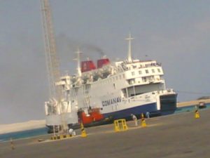 rdly, the port of Osman Digna. This port is located in the famous and historical city called Swakin distanced about 60 km from Port-Sudan. There are 9 berths, 784 meters long with a capacity of 3,000,000 tons per year. There are two halls passengers’ terminal; one the arrivals and the other one for the departures. There is also an area adjacent to the arrivals hall about 1,004 for keeping and the passengers’ luggage and it under the control of shipping agents.
| Berth no. | Length(m) | Depth(m) | Usage |
| 1 | 156 | 9 | Passengers +RO/RO+CG |
| 2 | 130 | 9 | Passengers +RO/RO+CG |
| 3 | 106 | 9 | Passengers +RO/RO+CG |
| 4 | 60 | 8 | Livestock + GC |
| 5 | 100 | 12 | Livestock + GC |
| 6 | 104 | 8 | Livestock + GC + Dry bulk |
| 7 | 34 | 8 | Livestock |
| 8 | 34 | 8 | Livestock |
| 9 | 24 | 8 | Passengers + RO/RO + GC |
EQPT and machines: –
| Type | Number | Tonnage |
| Fork lifts | 7 | 8 |
| Fork lifts | 8 | 3 |
| Shunters | 3 | 0 |
| Tug master | 3 | 0 |
| Trailers | 10 | 0 |
| Water tank | 3 | 0 |
| Generator | 7 | 0 |
| Mobile crane | 2 | 25 |
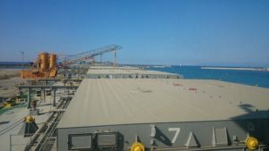 Fourthly, the green harbor is located on the east side of Port-Sudan, main quays latitude is 19 0 36’ 36’’ north and longitude 370 14’ 30’’ east. It is established in a long term project consists of establishing extra special quays to serve different port handling operations. Objectively, the green harbor serves; dry bulk handling, containers and seeds which enables Port-Sudan to avail more areas for more port operations and increases the port capacity. It has a private marine entrance for accommodating ships. It contains 2 berths and they are extended to 548 meters and 180 meters with width of 14,2 meters. Approximately, the area of green harbor storage is 436,000 m2 and it can accommodate ships of 50,000 tons.
 e last port is Al-Kheir which is dedicated to petroleum support for ships.
Type |
HKS–2125 |
HKS–2100 |
HKS–2175 |
Quantity of hooks |
Tow hooks |
Tow hooks |
Tow hooks |
Normal pull of single hook |
1250KN |
1000KN |
750KN |
Pull of electric captsan |
20KN |
20KN |
10KN |
Line speed of electric capstan |
30m/min |
30m/min |
20m/min |
Motor power |
11KW |
11KW |
5.5KW |